Saturday (Apr 23)
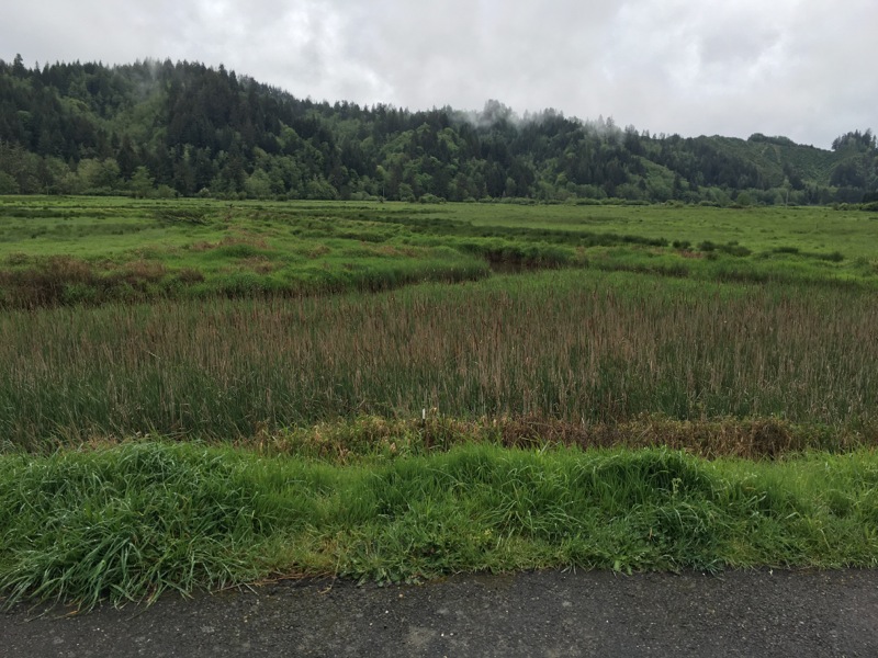
On this part of the coast there’s the beach, then a 30′ high natural levee (foredune as the sign calls it :), then about 200 yards of low scrub, then miles of impenetrable bay/cypress/waxmyrtle thickets and even swamps – same stuff I hiked through two nights ago at Sutton Creek. My parking lot is in the low scrub zone, and I angled myself so that I look out over it (and not the RVs and dunebuggies :). The moon was full last night and it was spectacular looking over that expanse of vegetated nothing. Most of the night was cloudy so it was diffuse moonlight rather than surprising glare you get from the actual orb, but it sure was pretty! Later on it rained. It’s gloomy and windy this morning, with the threat of rain any minute.
Finally I tear myself away. A short 12 minute drive across the bridge into Coos Bay and I am back at the Smiling Dog Cafe, with it’s free coffee and wifi and good, cheap food. I love this place.
Researching options and over-planning can wear a person out, but sometimes the fruits of that worrying and thinking are pretty cool, and that’s what’s happening now.
New plan will be to head down the much milder I-5 corridor, down to McCloud/Burney and then my usual Susanville route.
But today’s last bit of research shows a lonely BLM icon that I hadn’t noticed! I had resigned myself to the boring looking but new to me (yes, a seeming contradiction) route out of Coos Bay, but this place means that I have to retrace for the third and sometimes fifth times up through Reedsport and all that hyperactive law enforcement, to Route 38 and the very beautiful lower Umpqua Valley. I have a very low key, pleasant drive. The Umpqua Valley is beautiful. There are no elks at the elk viewing area this afternoon, but the red-winged blackbirds came very close.
WHUFU page for: Tyee Rogue River Campground
Right on the Umpqua, at the very edge of the little hamlet of Oakland OR. It's small so it could fill up fast, but darn it's a sweet little spot tucked away in an unlikely part of Oregon.
I came here on an August Friday and it was FULL. It's a perfect place to go tubing on the river, so I'm (sad but) not surprised.
tonight:
#5 is at the end of the upper loop and could not be more perfect (unless you need to be near the bathroom, which thankfully I don't anymore :)
Right on the Umpqua, at the very edge of the little hamlet of Oakland OR. It's small so it could fill up fast, but darn it's a sweet little spot tucked away in an unlikely part of Oregon.
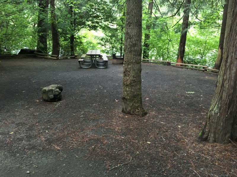
Man this place is nice! Reminds me of Susan Creek the BLM campground I was going to stay in before the weather change. By far the most deluxe BLM campgrounds I’ve ever been in anywhere, and they’re both in the same area and have the same deal where local Boy Scouts or Junior Achievers of some sort put in tons of volunteer effort to make it really nice. Love it! Has a good solid WPA, civic pride feel to it.
Sadly, it also has it’s own set of creepy hillbillies, who have been here long enough that they leave their toiletries – toothpaste, soap, shampoo – at the campground water spigot, Never seen that before…. I can’t wait for the economy to get better so all these people have a home.
I took what feels right now like a lot of cool-ish arty videos and panoramas. I guess I took good regular photos also, but today’s insight is that for what I like to convey – the feeling of being there – those two modes are very useful additions. woo!.
Around sunset, the rain drove me inside the van, working with the door open sitting on my cooler. Then it eventually forced me to close the door. Now I’m cozy inside, happy with the day I had, listening to big fat raindrops that have collected in the high branches of the Douglas firs, fall and splang against the roof of the van.
Sunday
The splanging continued all night and morning. If I were parked out in the open, it would have been a quiet mist or drizzle, but like I say, the trees collect it into big, splanging units.
Now, 10:30, it’s raining hard, and for a while even hailing! This make me glad to be having crappy weather safely on the west side of I-5, rather that having it in the much wilder mountains east of there.
I want to see the Warriors game at 12:30 today. The Tap Rock in Grant’s Pass would be the perfect place, good food, good wifi, and lots of TVs, but it’s a couple of hours away. Yelp didn’t show me anywhere remotely as promising between here and there, so that’s where I go. It worked out really well … until a couple of locals came in and started agitating for hockey. Not on any of the other four TVs, but on my TV. Annoying, it got me fully into “get off my lawn” mode for a few minutes (which I don’t really like), but I was leaving anyway at that point, so I just moved on and tried to put the bad vibes behind me. I will also restrain myself from any generalizations about hockey fans. :)
I followed OR 99 along the Rogue until it forced me back onto I-5. Soon I was needing to get rid of the beer and coffee I soaked up at the Tap Rock. My angels were guiding me! I pulled off at the next rest stop, which was ….
WHUFU page for: Valley of the Rogue
between I-5 and the Rogue River, a very pleasant, user-friendly place. The only loops open happen to all have full hookups, but the nice folks agree that if you don't use 'em you don't pay for 'em, so it's a $15 tent site!
Great hike along the river, followed by my first shower since the hot springs, so I am feeling pretty good!
tonight:
Summer rates, but also, all the loops are open, so I am in an actual tent site. Forbidding sign says "One night only." Works for me! Still pretty and green and grassy, and I-5 is still 200 yards away.
I’ve stayed here before! I did a drive-by on the registration kiosk to see what the rate is nowadays – $19. I can live with that! So, just like that, I bailed out on my 2.5 hour drive to McCloud. Pay my $19 and stop now, at a place I know is pleasant. Slowly I’m learning how to chill out. Coolish and windy and spits rain every now and then. I think I’ll go for a walk.
It was a good walk! 9,000 steps my app tells me! The moon does not rise till 10 pm or so, so I’m glad I’m walking in the wide open spaces.
I washed away the exertion with an excellent State of Oregon shower when I returned. This one had actual knobs rather than the buttons on timers, so it was a deluxe experience!
Monday
I-5 sounds pretty much the same 24-7. Sunday afternoon, middle of the night, Monday morning – jut an amazing, never-ending stream of gas-burning engines on wheels. Also, it doesn’t feel like a Monday to me, I’m on vacation! It was pretty cold last night, the heat came on a lot. It’s probably even colder in the mountains, where I didn’t go.
On my way out of the campground I hopped over to the next site to top off my water tank from the handy threaded spigot I noticed there. Immediately I got hassled by some hard-ass dude who seemed think God had willed him that spot, even though I was in it and he wasn’t. I kind of deferred because I thought he might be with the park. Pretty sure he wasn’t, so basically he rolled me by being a bigger asshole, and I am left with some resentment about not standing up for myself. No big deal, but part of a well-run life for me is not spending time getting bullied by belligerent assholes, so two in less than 24 hours is kind of a warning bell for me. Three assholes would make it a trend, and we don’t want that trend.
Soon I was back to my usual self, only occasionally thinking about last night’s asshole or today’s asshole. Because I stopped early last night, I have a very easy drive today. I celebrate by following OR 99 to its terminus at the south end of Ashland. I feel I know this part of Oregon a little better now. 99 takes you right through downtown Medford. I got it in my head that I wanted the experience of real town’s coffee house rather than a swishy, artsy student coffeehouse in Ashland. Probably a mistake. The first place I treid on downtown Medford had the lovely name Limestone Coffee. It was so pretentious that I just thanked the lady and moved on.
The second spot, Downtown Coffee was as funky as you could ask for. You walk in the door and all there is is a landing for a flight of stairs. Business is done and coffee is dispensed by a very tall hippie dude in the alcove under the stairs, who seems in constant danger of banging the back of his head on the slanted underneath of the stairwell. Then you take your cup of coffee and walk up a flight of stairs where there are three tables and seven chairs, and that’s it! The coffee was good and cheap and so was the wifi, so it was fine, but … funky. I’ll bet it’s really hot and stuffy in the summer.
On the other hand, Ashland is awfully pricey. I got my food for the day at a place called Sammich, where the sandos are > $12 each. The dude told me I could sub potato salad for chips on each, but did NOT tell me he was charging $2 extra each. So a hot sando for here and a cold sando for later was a jaw-dropping $33 ! To the point of the last paragraph, there was also a nice looking coffee place in the same set of buildings … if only I’d known I could’ve done one stop shopping and avoided searching for parking in downtown Medford and carrying my coffee up a flight of stairs.
South of Ashland, 99 finally runs out and funnels you back onto the interstate, for a high speed drive over Siskiyou Summit and down into California for the next 70 miles or so. Actually not true – a few miles into California I exited and followed CA 296. It is a spectacular drive that starts along the Klamath River, then follows the Shasta River from it’s confluence with the Klamath, then follows Yreka Creek to Yreka. It was quite a pleasant drive, much better than waltzing with semis on the interstate for those miles. Too bad there’s no campgrounds down there.
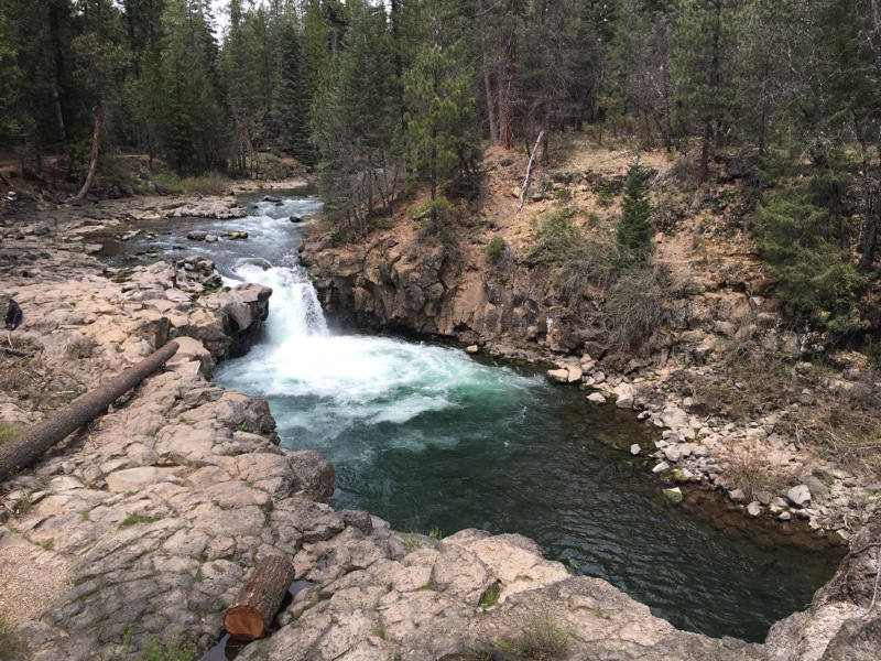
WHUFU page for: Fowler's Camp Campground
On the McCloud River, within hiking distance of the three waterfalls. Apparently heavily used in the swimming months, but pleasantly uncrowded tonight.
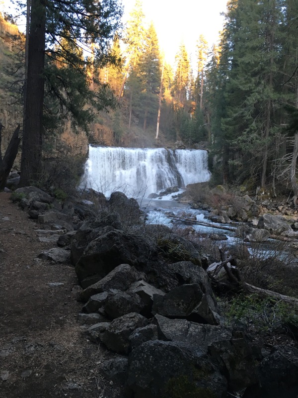
The hike to Lower Falls is less than a mile and very scenic.
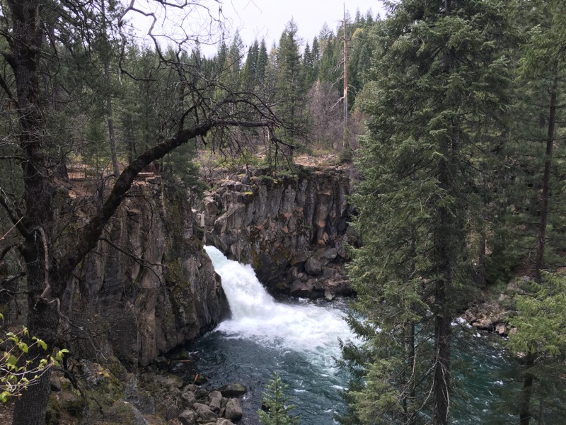
Hike to Middle/Upper Falls is a little more than a mile. You can walk the paved road back to make it a loop if you wish.
tonight:
Site 24 is great. It's slightly annoying that the waterfall trail runs between the campsites and the river, so people occasionally walk between me and my excellent view, but that's a small quibble.
Another great hike, made it all the way to the Middle Falls viewing platform. Followed my favorite script by walking back on the road, I was able to not use the flashlight, and as a bonus, had great views of Mt Shasta in the waning light. Towards the end I wasn’t sure I was on the right road, so I got the bright idea to is “Find My iPhone” to find my laptop or iPad, allowing my to effectively home in on the van. Brilliant idea :), but it failed to find either … because they have no connectivity other than internet? Oh well, research topic.
Tuesday
Got down to 28° last night, still pretty chilly this morning. The mountains in Oregon yesterday had a fresh dusting of snow, again confirming my decision to stay in milder climes.
Long day. Maps told me it would be 3.5 hours to get home, and about the same to get to Sierra Hot Springs. That’s more driving than I like to do, but those are my choices. I want to be soaking in the hot pool tonight.
I dawdled in bed, dawdled around the campground, visiting the other two Falls I missed last night. For completeness I have included a picture of each falls above. Not great pictures, but there they are.
Every time I’m on this road I find myself making the ten-mile detour to Burney for breakfast and wifi. Breakfast at the Blackberry Patch(?) is nothing special, but life isn’t quite right if I don’t get my daily dose of wifi so I end up doing it.
My Sierra Hot Springs calculation is becoming untenable. Driving straight there from here would get me there at 7:30-8. I pulled off at the shortcut turnoff (which I am not sure is even paved all the way) and meditated on it. Made the decision to punt and go home. So here I am writing this in my comfy chair, frosted mug at my side, stupid TV blaring at me, catching up on the Warriors and politics, instead in the quiet and cold of the van in Sierraville. I’m ok with this result.