Sunday (Sep 9)

Fort Benton turns out to be a really interesting and stylish little town … who knew! Traveling east from here, the next few days are a succession of beat-up little cow towns with not much going on, which made me appreciate it all the more in retrospect.

Most of the rodeo crowd was gone by the time I got going in mid-morning. I enjoyed the peace and quiet by the river for a while then drove downtown to restaurant/coffee house downtown I had noticed last night – Wake Cup Coffee. The man and woman carpenter pair are just where they were last night, working on the old west style porch they are adding to the front. The Wake Cup people were super nice. The lunch special was really a breakfast – something involving eggs and bacon – which suited me perfectly. It was really good. Unlike the places I stayed in the next couple of days and most of the Corn Belt, I would love to come back here some time.
I peeked in at the reconstruction of the actual Fort Benton, but they wanted money. It didn’t look all that awesome anyway. I did go back to the BLM Visitors Center, which had some good geology exhibits. It’s all sandstone and limestone around here.
Once I got on the road it was a long-ass drive. The first potential place to stay I came upon was in the town of Havre, but it was very sad looking and right next to the highway. I decided to press on another 65 miles to the next potential place, which was a good move.
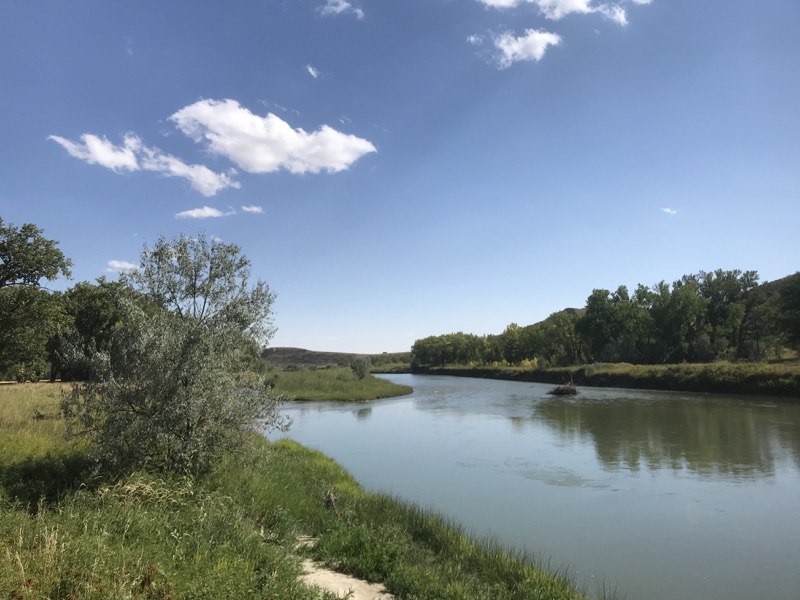
My Lewis & Clark moment of the afternoon came when US 2 crossed the Marias River. Going upstream, this was the famous place where the Lewis & Clark crew came upon confluence of the Marias and the Missouri and could not decide which was actually the Missouri. Famously they took a vote on which way to go, allowing the black guy and the Indian woman to vote. According to the sign, I am crossing the Marias a couple of miles upriver from the actual spot. It would be nice to see it, but it appears to be a not that great gravel road, and I am just not feeling it today for a gravel road excursion.
So … onward to the town of Malta, where there is a city campground that sounds nice on AllStays.
WHUFU page for: Trafton City Park
A modest city park in downtown Malta. In a grassy area between the fairgrounds and the Milk River you can camp for $5 a night. Pretty sweet.
tonight:
There are some picnic tables, lots of playground equipment - swings, see-saws. You can pretty much park wherever you want and stay there for the night.

I do a drive-through on the “campground”, and it is really a city park attached to the fairgrounds where they just let you sleep in the park for $5. It looks completely user-friendly. I am pleased.
However I do want to get dinner. This part of town is separated by the highway and the railroad from downtown Malta such as it is. I am on a roll with breaking out the bicycle, so I gave a thought to parking and biking. But this would not be a pleasant ride – busy highways and railroad underpasses. So I punt on parking and biking. I just drive over to “town” and figure I’ll pick out a spot to park afterwards.
Looking to repeat my magical steak dinner at the Banque Club last night, I decide that of the meager dining choices the Stockman’s Bar is my best bet. It is the only non-chain restaurant in town that is open according to Yelp. No magic tonight. It was meh on every front – the food, the beer, the ambience, the bored server – all meh. But I got myself fed. Back to the park.
It was very nice! The first place I parked was near a funny little building and had a faint smell of sewage. I decided that building had something to do with the town’s waste management, so I moved to a spot that didn’t smell. The new spot was infinitely better by virtue of being next to the basketball court! I was very happy there. I even shot hoops at the basketball court for a few minutes. Yes I brought my ball on the trip this time!
Monday

I have been having really good luck patronizing “the only coffeehouse in a small town” so far on this trip, but my luck ran out today. This place just wasn’t very good. The coffee was awful, and the server lady was extremely stressed. She wasn’t mean or actually rude, but she was so stressy I felt like a real shit just for going back and asking her what the wifi key was. And so of course, she got the wifi key wrong – that’s how a stressed out server stays stressed out! We had to bring the cook out front to tell both of us it was “crossroad1“, NOT “crossroads1“. I guess my clue should have been that the place is called The Crossroad. The name made me think this is a Jesus place. Whatever … the wifi was ok, the coffee was coffee, and the sandwich was inexpensive … and that’s the best I can say.
I drive east for seven miles to:
WHUFU page for: Bowdoin NWR
Nice place, not much wildlife action today, but the 15 mile Auto Loop Trail was very pleasant and interesting to me, since I am in unfamiliar habitat. Picturing what it was like for the native Americans, that sort of thing.
tonight:
To me it is so obvious it doesn't need to be discussed that a loop drive around a lake should go counterclockwise, so the driver's side is next to the lake. Not so obvious to these folks.
I took the marked Loop entrance from the Refuge Headquarters parking lot, and after a half mile it became clear that I was going to circle the lake in THE WRONG DIRECTION! Simply unacceptable. I executed an 8-point turn to get the van turned around on the narrow gravel road and turned back. There was nobody manning the desk at Headquarters, so I had to raise my voice until I roused a nice young fella from the back to tell me that what they think of as the exit (but should be the entrance :) is an unmarked gravel road off to the left a few hundred yards back up the road.
I followed his directions and did the tour with the marshland and prairie which the tour encircles on the DRIVERS side as it should be. What is wrong with these people? :)

I put in my two hours of driving the endless plains to get to the next interesting place, Fort Peck – built for workers at “Fort Peck Dam, … the largest embankment dam in the United States with the fifth-largest man-made reservoir.” … with the unimaginative name of Fort Peck Dam Lake. There are three or four Corps campgrounds in the neighborhood, and with the Corps trademark lack of signage it was hard to figure out what was going on. The first campground I went to had closed for the season last week. But with patience and perseverance and the blessing of phone reception in the middle of nowhere I ended up at a great campground:
WHUFU page for: Downstream Campground
A very pleasant campground in the Army Corps style, which is to say well-engineered down to the small details.
There is a little network of paved trails over to the Dam Glorification/Dinosaur Museum and through the marshes.
tonight:
The Tent Loop is the bastard stepchild of the campground, gravel instead of paved, and a sad little pit toilet. But a few hundred yards back towards the entrance, amid the big rigs and their partying groups of hunters, is a bathroom with flush toilets and oh glory! nice, free showers.

As I fooled around at the kiosk I saw a fellow cruising around on a recumbent bicycle. This reminded me that I actually am carrying a bicycle in my van, and this would be a good place to use it! So after I got settled, I unpacked all the little boxes, shoes, and dirty laundry that had accumulated around it, pulled it out and put it together. It was simply spectacular to use it tonight!
Tuesday

I am feeling so perky about having the bike assembled that I took another spin around the rest of the trail that I missed last night. My cardiologist would have been proud of me :) Again, without the serendipity of seeing the recumbent bike dude I am pretty sure I wouldn’t have thought to do it … so good for him and shame on me.

Then is was time to leave and return to good old US 2 and the town of Glasgow to try to find a sandwich place that doesn’t suck. I was … 65% successful. The coffee at The Loaded Toad was terrible, as is apparently the norm in these parts. Certainly the name of the place would have repelled me if there were other good choices. But the wifi was good and the sandos were cheap enough that I ordered a $6.50 roast beef sando for tonight. So dinner is taken care of! Also on the plus, it’s in a cool space in a nice old downtown building. There’s upstairs seating, but I wanted to sit downstairs, so I had to carve out a spot amidst two tables of local ladies having luncheon get-togethers. Having a disreputable-looking old dude with a laptop (me!) within earshot didn’t seem to please them, but that’s just too bad. :)
The place I’ve identified for tonight is only about 2 hours away (about 1/6 of the width of Montana): and it’s only 2 pm, so I decide to visit the Glasgow Public Library again for a little Flickr work. Finally got going and finally made it to the other end of Montana. The last mile marker on US 2 was 676 – not Texas wide, but still pretty damn wide! I am now in North Dakota. About 12 miles south of the highway was:
WHUFU page for: Fort Buford Historical Site
12 miles south of US 2, the east-west highway I've been driving for five days. Totally worth the detour.
tonight:
At first I thought the historical site parking lot was the campground, but then I noticed a sign at the gate to the gravel continuation of the road. There's a llttle three acre field of cottonwoods and grass with a few picnic tables that is just perfect.


The sign tells me that Fort Buford is where the famous Hunkpapa Sioux leader, Sitting Bull, surrendered in 1881. This is one of those modest little out the way places that turns out to be really, really cool in its quiet way. Just a little copse of cottonwood trees, nobody around. The old Fort Buford is long gone, but the comandant’s house is refurbished and is the visitors center. There’s another little house with an amazing horse sculpture out back that turns out to be a Masonic Lodge. An old military cemetery is on the next hill. A mile away is a BLM Interpretive Center for L&C and the Confluence of the Missouri and the Yellowstone, and a boat ramp for the united rivers.
I break out the bike (two nights in a row) and explore all this. So much fun. As I said, not a single human or vehicle encountered the whole evening.
Wednesday

I hate to leave my peaceful, interesting little hideaway of historical, geological and artistic marvels, but the road calls. I have had a very nice run of staying in places that are pretty much perfect! This is the reason I do these trips. When I’m in regular life in Reno, thee are the things I look back on with fondness and sometimes longing – these quiet, often isolated places were I spend the evening.
The BLM Center is open this morning, so I drop in for some local knowledge … and get some! The fall colors I’m seeing are the ash trees, they always turn before the cottonwoods. Over the next few days I confirm this little nugget. Also, all these dams and lakes have really messed up the Missouri’s ecosystem. The Yellowstone is un-dammed (the longest river in the US to be so blessed), so it’s a lot more like it was in the old days. I drop down the the boat launch on the way out, and there’s about 20 people and as many trucks, they’re getting ready to drill for oil!

A diagonal county road takes me more or less straight into the suburbs of Williston ND, the big city in these parts. It also turns out to be the epicenter of the Baaken Shale Oil Boom. I’ve read about it, now I’m in the middle of it. Wiki tells me that Williston has doubled in population from 14.7K to 30K in the last few years. Meg-A-Latte was the slightly unfortunate name of the coffee shop I found. Overcoming that dorky name, it turned out to be mellow, and a pleasant place to hang out, with nice barristas. They were so nice that thought I could get away with quizzing them about Williston and to oil boom. Both of them were children of the boom, they had moved here in the last six years. One said her dad is an oil worker, just follows the work. I lucked into a shift change, so I got another pair to quiz. Ditto for one -she was a new resident, oil boom kid, but the other was born and bred Williston. She thought it was around 6th grade when things started picking up.
I’m sure there’s a downtown somewhere, and I’m pretty sure it’s small and most of the action in this busy place is out here in the suburbs, New four-lane roads with endless stop lights and giant diesel trucks are everywhere. On the way out of town I there was an (older) billboard advertising that this is the home of Phil Jackson. There was no good place to stop, which was too bad, because I wanted a picture of that! That rang a bell from long ago, of the Knicks drafted him out of U of North Dakota.
On the way into town I caught a sign for Theodore Roosevelt National Park to the south. At the coffee shop I googled around and discovered this is not far away by North Dakota standards, about 60 miles south of there. It was utterly not on my radar until two hours ago, but now it’s clear that’s where I should go tonight! Take US 85 South south through oil boom hustle and bustle to the turn-off for the North Unit of the TRNP.
WHUFU page for: Juniper Campground
The is the campground of the North Unit of the TRNP. It's quite pleasant.
tonight:
Site 6 is on the inside of the loop, so you are watching everybody else's business and they are watching yours. But it has a nice open feeling.
The sites facing outward into the grassland (maybe bison!) were all full.

There was a low tech Visitors Center at the park entrance, and there I saw a happy sight: recycling! I have been carrying beer and wine bottles literally since Washington state, 800 miles ago. It was a joy to plunk them all into the bin. The campground here is pretty good by National Park standards. The parking pads were level and the bathroom was modern. As noted above, of the available available sites the one that appealed to me most was a pull-through on the inside of the loop. There were outside the loop sites where your picnic table was in a thicket of trees and willows. Certainly more private, but I felt like being in the open tonight, not in a thicket.

There are a couple of fun-looking 3-4 mile hikes, but it’s too late in the day for that, so I settle for coupla miles noodling around the campground area. Walk over to Little Mo, the Little Missouri River, whose beauty and abundance is what captivated ole Teddy to his hunting lodge/ranch here in the first place. There was a group of mule deer hanging out who spooked at the first sight of me. Them running made me run to get a better look at them, so there was a lot action for about 20 seconds! It was impressive to watch them scramble up the sandy 25′ riverbank on the far side.
Then there was a 1.4 mile nature trail that fit the amount of daylight I have left just perfectly. It went up a little rise so I got a great view of the area. There was a CCC shelter by the picnic area. Those things always give me emotions, partly for the connection to who built them, but mostly for the lost greatness of America. We used to do big things. and when the economy chewed up peoples lives we helped them. But that was before the modern R party.
Back to the van after dark, and slept well.